
Best hiking routes
View Contents
ToggleTenerife is an island that has everything. It has sun, beach, culture, gastronomy, luxurious hotels, little lost cabins, nature and mountains. And of course it also has trails, here you have the best selection of trails on the island.
Sendero de los Sentidos
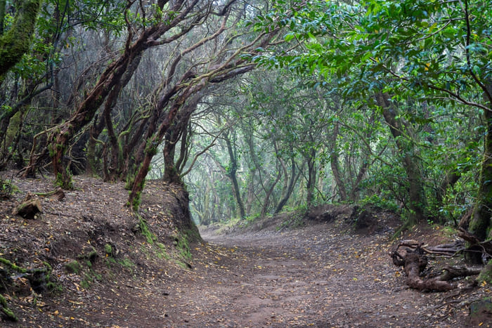
The Path of the Senses is a hiking trail that offers a unique and interactive experience in the heart of the Anaga Rural Park, in the northeast of Tenerife. This park is known for its lush laurel forest, a type of moist subtropical forest mainly found in the Canary Islands and part of the UNESCO Biosphere Reserve network. The Path of the Senses is designed to engage all senses, allowing visitors not only to see nature but to truly feel, hear, and touch it.
Features of the Path of the Senses
Routes Adjustable to Different Levels
The Path of the Senses is divided into three routes of varying lengths and difficulty, making it accessible to all types of visitors, from families with children to experienced hikers.
- Route 1: This is the shortest and most accessible, suitable for everyone, including people with reduced mobility. It features several interactive stations where you can touch, smell, and listen.
- Route 2: Of medium length, this route requires moderate mobility and offers additional sensory experiences, including panoramic views of the forest.
- Route 3: This is the longest and least accessible, recommended for those looking for a more intense and challenging experience in nature.
Sensory Experiences
Along the routes, visitors encounter sensory stations designed to stimulate different senses. These include panels with natural textures to touch, herbs and flowers to smell, and acoustic tubes that amplify the sounds of the forest, such as the singing of birds and the rustling of the wind.
How to Get There
The Path of the Senses is located near the Cruz del Carmen Visitor Center in Anaga. To get there from Santa Cruz de Tenerife, take the TF-12 road towards the Anaga Rural Park. There are clear signs directing visitors to the visitor center’s parking area, where the trail begins.
Clothing and Recommended Equipment
- It is essential to wear comfortable footwear suitable for walking on forest trails, which can sometimes be wet or slippery.
- Given the variable climate in Anaga, it is advisable to wear several layers of clothing, including a waterproof jacket.
- Don’t forget a camera to capture the beauty of the forest and binoculars if you are interested in bird watching.
Additional Tips
- Although the Path of the Senses is well signposted and designed to be safe, it is always a good idea to inquire about the weather and trail conditions at the Visitor Center before starting the hike.
- Carry enough water and some snacks, especially if you plan to take the longer routes.
- Respect the natural environment by avoiding leaving trash, not taking plants or rocks from the place, and staying on the marked paths to protect the forest habitat.
- This is one of the trails that can be done with children without any problem.
Sendero por Vilaflor y Paisaje Lunar
The Vilaflor to Lunar Landscape Trail, also known as the Lunar Trail or Route of the Roques de García, is one of the most fascinating hiking routes in Tenerife. This unique trail takes visitors through forest and volcanic landscapes to an area known as the Lunar Landscape, famous for its extraordinary formations of eroded stone that resemble an extraterrestrial terrain.
Features of the Trail
Route and Difficulty
The trail starts in the village of Vilaflor, the highest settlement in Spain, located at approximately 1,400 meters above sea level. From here, hikers follow a route that winds through Canarian pine forests and high mountain vegetation areas, gradually ascending. The route is about 16 kilometers round trip, with moderate difficulty, mainly due to its length and the gradual change in altitude. It is suitable for hikers with a reasonably good fitness level.
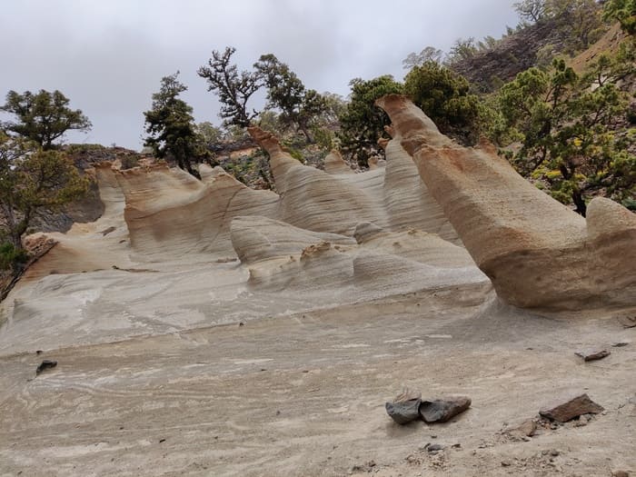
Lunar Landscape
The highlight of this route is the Lunar Landscape, also known as Los Escurriales. The formations are the result of the erosion of layers of volcanic ash, which has created whimsical pillars and shapes in shades of white and ochre. These structures dramatically contrast with the blue sky and surrounding vegetation, offering spectacular photographic views.
How to Get There
To get to the start of the trail in Vilaflor, you can drive or take a bus from the main tourist centers in the south of Tenerife. Parking is available in the village. From there, follow the signs to the trail leading to the Lunar Landscape.
Clothing and Recommended Equipment
- Sturdy hiking footwear is essential, as the terrain can vary from forest trails to rocky and sandy paths.
- Sun protection is crucial, as well as carrying enough water, as there are long stretches without shade or water sources.
- Due to changes in altitude and variable conditions, layered clothing is advisable. A light jacket may be useful, especially in the cooler months or for the early morning hours.
Additional Tips
- Start early in the morning to avoid midday heat and to ensure you have enough light for the entire hike.
- Carry a map or download a hiking app, as although the path is well signposted, it is always useful to have a backup guide.
- Since it is a popular route, try to visit during the week to avoid crowds.
Sendero Barranco de Masca
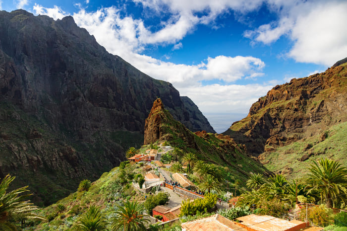
Masca Ravine is one of the most spectacular and popular trails in Tenerife, offering adventurers the opportunity to explore one of the most breathtaking landscapes in the Canary Islands. Located in the northwest of the island, the ravine winds from the picturesque village of Masca down to the rocky coast, where the towering cliffs drop abruptly to the Atlantic Ocean.
Features of the Masca Trail
Route and Difficulty
The Masca Ravine trail is known for its wild beauty and challenging terrain. It starts in the small village of Masca, located about 600 meters above sea level, and descends through a deep ravine to Masca beach on the ocean. The route is approximately 4.5 kilometers long but can be quite challenging due to its uneven and often slippery terrain. The hike takes about 3 hours to descend, but the total time can vary depending on pace and stops to enjoy the scenery.
Stunning Landscapes
The ravine is flanked by gigantic rock walls and is covered with lush vegetation, including endemic species of the Canary Islands. The trail offers spectacular views of unique rock formations, local flora, and, if you’re lucky, you might spot some native birds like the kestrel.
How to Get There
To get to Masca Ravine, most visitors drive or take an organized tour from Santiago del Teide. Since parking in Masca is limited, many people opt to leave their cars in Santiago del Teide and use a taxi or a bus service to reach the trailhead.
Clothing and Recommended Equipment
- Sturdy hiking footwear is crucial as the path is rocky and can be slippery, especially after rain.
- Although the ravine provides some shade, it is recommended to wear sun protection, a hat, and bring enough water to stay hydrated.
- Don’t forget to bring a swimsuit and towel if you plan to cool off in the ocean at the end of the trail or if you wish to take a boat from Masca beach to Los Gigantes, which is a popular option for returning.
Additional Tips
- Given the popularity of Masca Ravine, it’s advisable to start the hike early in the morning to avoid crowds and midday heat.
- Be sure to check the status of the trail before your visit, especially after heavy rains, as parts of the path may be inaccessible.
- Consider hiring a boat taxi to take you from Masca beach to Los Gigantes. If you don’t do this you must walk up the path you just came down, the climb being much harder than the descent.
Cruz del Carmen - Punta del Hidalgo
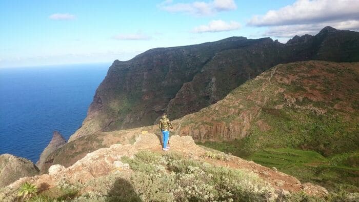
The trail connecting Cruz del Carmen with Punta del Hidalgo is one of the most spectacular routes in Tenerife, traversing the diverse landscape of the Anaga Rural Park. This area, recognized by UNESCO as a Biosphere Reserve, is famed for its rich biodiversity and stunning landscapes that range from lush laurel forests to rugged coastal cliffs.
Features of the Trail
Route and Difficulty
The trail, known as the PR-TF 10, starts at Cruz del Carmen, accessible from La Laguna and well-signposted from the park’s visitor center. From there, it descends to the northeastern coast of the island, ending in the coastal village of Punta del Hidalgo. The route is approximately 10 kilometers long and is considered medium to high difficulty due to its varied terrain and significant altitude changes. The total descent is about 900 meters, which can be demanding on the knees and requires good physical condition.
Natural Attractions and Landscapes
The trail offers a unique opportunity to experience the transition of ecosystems, from the dense laurel forest, characteristic of Anaga and one of the last refuges of this ancient type of forest, to the more arid coastal vegetation near Punta del Hidalgo. Along the way, hikers can enjoy panoramic views of the Anaga mountains, the Atlantic Ocean, and on clear days, views towards the neighboring island of La Palma.
How to Get There
To reach the start of the trail at Cruz del Carmen, you can take a bus from La Laguna or drive and leave your vehicle in the ample parking available. For the return, there are regular bus services from Punta del Hidalgo back to La Laguna, facilitating logistics for those doing the one-way trail.
Clothing and Recommended Equipment
- Appropriate hiking footwear is essential, as the trail includes slippery sections and loose stones.
- Due to the variability of the weather in Anaga, where fog and rain are common, it is recommended to wear waterproof clothing and several layers to adjust to temperature changes.
- Do not forget to carry enough water, snacks to replenish energy, and sun protection, especially for the final part of the route that is more exposed and sunny.
Additional Tips
- Consider carrying a trail map or downloading a digital map on your mobile, although the route is well signposted, it’s useful to have an additional resource.
- Since the trail is popular among hikers, it’s advisable to start early in the morning to avoid crowds and enjoy the tranquility of the forest.
- If you are interested in the local flora and fauna, carrying a field guide can enrich your experience, helping you identify the various endemic species you will encounter along the way.
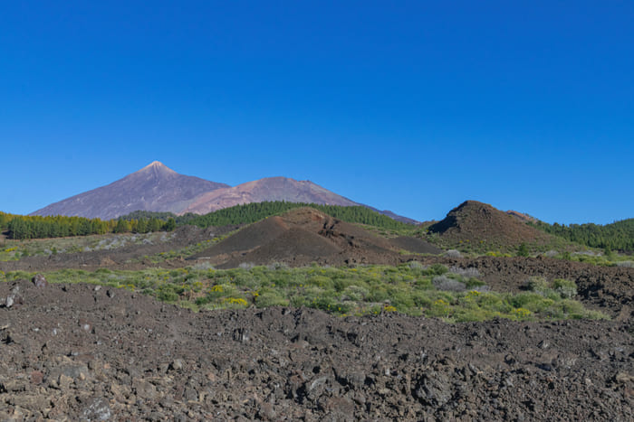
Montaña Blanca
The Montaña Blanca Trail, also known as Trail 7, is one of the most popular routes for ascending to the peak of Teide, the volcano and highest point in Spain. Located in the stunning Teide National Park in Tenerife, this trail is not only a physical challenge but also a unique opportunity to experience the volcanic geology and spectacular views offered by the island.
Features of the Montaña Blanca Trail
Route and Difficulty
The Montaña Blanca Trail begins near kilometer 40 on the TF-21 road, which connects La Orotava with Teide National Park. It is a linear route that gradually rises and is known for its impressive lunar landscapes and peculiar rock formations, such as the Teide eggs, large spherical volcanic rocks scattered along the path. With a length of approximately 8 kilometers up to the Altavista Refuge, this trail is of moderate to high difficulty, depending on the hiker’s physical condition and the effects of altitude.
Altitude and Weather Conditions
The trail starts at an altitude of approximately 2,350 meters and ascends to 3,270 meters at the Altavista Refuge. As high altitudes are reached, it is common to experience significant changes in weather and temperature, even within the same day.
How to Get There
To get to the start of the Montaña Blanca Trail, most visitors drive or take a bus to the TF-21 road. There is a small designated parking area for hikers at the start of the trail.
Clothing and Recommended Equipment
- Sturdy hiking footwear is essential, as the terrain can be rocky and uneven.
- Due to temperature variations and the strong wind often encountered at higher altitudes, it is crucial to dress in layers. Include a wind and waterproof jacket.
- Sun protection, sunglasses, and a hat are indispensable due to the intensity of the sun at high altitudes.
Additional Tips
- Due to the altitude and length of the trail, it is important to acclimate properly before attempting the ascent, especially if you are not used to high altitudes.
- Carry enough water and energy snacks, as there are no water supply points along the way.
- Consider booking a night at the Altavista Refuge if you plan to watch the sunrise from the peak of Teide, which requires a special permit if ascending before dawn.